ALTO tower, built in 1915 and closed in 2012, was still hanging in there. It is slated for preservation, but the process of making it suitable for visitation and restoration is ongoing. Until that happens is sits unoccupied, at risk of vandalism and fire.

While I was on site, an NS PSR special descended the hill with C44-10W #8044 and C44-9W #9826 leading a manifest block ahead of a an autorack block, then AC44C6M #4483 before a long trailing block of RBMN coal hopper cars.


This long PSR monster stopped with the head end near the Rose Yard crew base, indicating an main line re-crew or tail end helper cutoff. As the sun was starting to set I felt it best to get back on I-99 and try to get ahead of the train and get a photo at the Tyrone station about 10 miles to the (railroad) east. Since my last visit, the Tyrone station renovations had been completed with a new platform and ADA parking spaces.


We parked for the Allegheny Valley branch train near the larger town of Brady, PA and the specific community of Phillipston at the site of the PRR Phillipston yard and engine terminal. The main railroad related artifact at this location is the former turntable that supported steam locomotive operations.


Although that concluded my hike, I did stop by FC tower in Falls Creek, PA to get some pickup photos I had missed on previous occasions.


This long PSR monster stopped with the head end near the Rose Yard crew base, indicating an main line re-crew or tail end helper cutoff. As the sun was starting to set I felt it best to get back on I-99 and try to get ahead of the train and get a photo at the Tyrone station about 10 miles to the (railroad) east. Since my last visit, the Tyrone station renovations had been completed with a new platform and ADA parking spaces.

Although the train I had encountered at ALTO did not appear, a replacement was provided in the form of an eastbound doublestack intermodal train with C44-9W #9913, SD70ACe #1116 and C44-9W #9581 leading.


We parked for the Allegheny Valley branch train near the larger town of Brady, PA and the specific community of Phillipston at the site of the PRR Phillipston yard and engine terminal. The main railroad related artifact at this location is the former turntable that supported steam locomotive operations.

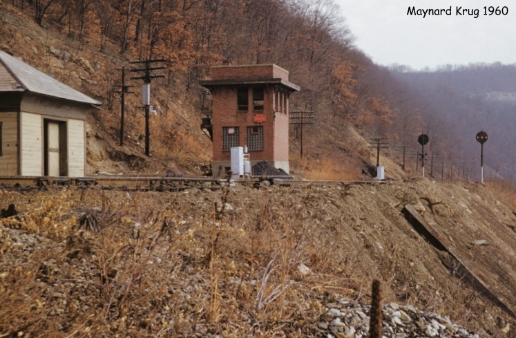
In 1915 the PRR completed a tunnel under a long neck in the Allegheny River valley that cut a couple miles and sharp curves off the route. The old route via Brady was cut back into a mile long stub serving the yard and engine terminal until the line was abandoned. The southern portal was also the site of BRADY tower, a WW2 vintage tower with a surprisingly modern CTC setup.

Today the tunnel is in the process of being stabilized for incorporation into the longer rail trail.

The crown jewel of this part of the train is the former PRR Red Bank coaling tower. Although these types of concrete monoliths are more closely associated with major coal hauling roads like the C&O, the PRR did construct a few. This one was likely constructed to avoid the hassle of running engines to and from coaling facilities down the Phillipston spur.


The coal, likely direct from nearby mines, would be loaded in this covered shed, then carried to the top of the structure via a hoist before being dumped into the bin and then dropped down into the tenders.


The coal tower is just north of the junction between the Allegheny Branch and the Low Grade Branch that would eventually intersect the Harrisburg-Buffalo main line. Some have speculated that this route served as an alternate Philly-Pittsburgh Main Line, but the only direct path was towards the Great Lakes port of Erie.

Red Bank was the location of an 19th century iron furnace facility with the remains of the old coke ovens still visible today.

The bridge over the Red Bank creek has also been repurposed for trail use.


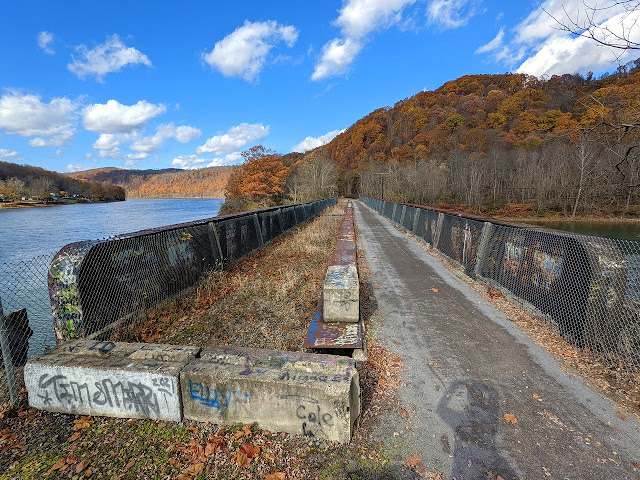
The goal of my hike that day was Allegheny River Lock and Dam #9, which is the last such lock/dam on the river (counting from the terminus of the Ohio in Pittsburgh). Built in 1934 and maintained by the Army Corps of Engineers, this represents one extremity of internal river navigation system that continues all the way to the Mississippi River outlet to the Gulf of Mexico. Although this is the last structure on this leg of the waterway, the actual limit of navigation is somewhere north of Brady.


Although that concluded my hike, I did stop by FC tower in Falls Creek, PA to get some pickup photos I had missed on previous occasions.

Next time I'll be back with the results of some time spent at Wyomissing Jct.
No comments:
Post a Comment