Search This Blog

Thursday, June 20, 2013

13-06-20 PHOTOS: Raton Pass

Well for anyone who read the URL's involved with my last photo set and was all excited about seeing cool mountain scenery were bound to be disappointed by the offering of flat prairie and semaphore signals. Well hopefully the seventh part of my third annual Cross Country Amtrak trip this time involving the Southwest Chief will prove more popular as we start off from the town of Raton, NM and travel up to the high point of the Santa Fe railroad at the Raton Pass on the border of Colorado and New Mexico.

You can find all the photos here about half way down the page.

Here we see the extended "smoke stop" capable platform as our train departs the Raton, NM station. Far in the background is Black Mesa and up in the foreground is a small number plated dwarf signals that serves as a pseudo-repeater for RATON interlocking located just out of right around a sharp curve. The curve also lets one get a view of downtown Raton which is so jumping you can see why everyone bailed out of Las Vegas.


The short stretch of two signaled tracks ends at EAST RATON interlocking at the foot of the climb up to the third and final 7000 foot summit of the trip. In the foreground is a combination Approach and Start Permanent Speed Restriction sign. The App PSR signs are tilted and the PSR signs are level. Also note the I-25 access road bridge is painted in jovial southwest colors which is pretty par for the course for NM DoT, what a great state. Finally i want to point out that the following section of the route was actually modernized about 10 years ago with brand new interlocking logic, signs, searchlight signals etc...only to have BNSF pull the rug out with their plans to abandon the line.


Moving up the hill we hit another rare signaled siding at KEOTA which also displays the effects of a forest fire that went through here a few years ago. At least this fire didn't seem to be one of the mega kind that burn everything down to charred stumps.


Here we see the entrance and exit of the 2700 foot Raton tunnel at the summit of the Santa Fe railroad. The NM.CO border is just at the northern end of the tunnel and marked with a small obelisk. Interstate 25 also uses the pass, but crosses at a slightly higher elevation and does not require a tunnel. The east/north portal of the tunnel can be considered the literal and figurative climax of the trip which again is strange for this is NOT the continental divide. 


Here is a video of my train entering and exiting the Raton tunnel and continuing on through WOOTTON interlocking


Both sides of the tunnel were marked by the Santa Fe railroad with large signs to inform the celebrities on the Super Chief that they were passing over the high point of the Santa Fe at 7588 feet above sea level. Below is the sign at the east portal. The west portal sign still had thee Santa Fe cross attached. Moving the train to the alternate Amarillo route will not only deprive several communities of a critical rail service, but also throw away a significant amount of cultural heritage. Back before the jet age this was the way for anyone who didn't want a prematurely shortened acting or music career to travel between New York and LA.


Some moW crews were out doing a little work on the line. I believe that Amtrak is currently responsible for any MoW costs between Lamy, NM and Trinidad, CO. Like I said before this part of the line was given some capitol investment by BNSF before they decided to pull the plug so maintenance isn't a huge problem as Amtrak's two trains a day don't cause much wear and tear. 


The two engines for my train, P42DC's #167 and #118 rounding the 90 degree curve east of the tunnel on the long downgrade with I-25 in the background. They are passing another ATSF info sign, but I didn't catch what was on it.


View of the curve and the sign and I-25 and a mesa out the back.


S-Curve with I-25 and the mesa.


GALLINAS interlocking is the first set of two main track crossovers that my train passed since DALLIES interlocking way back in the morning about 8-10 hours ago. Note the accommodations for signal maintainers during periods of extreme snow. This is the sort of upgrade and renovation process that has been lost with the new throw away culture that just replaces everything with new hardware.


What can I say, speeds over the pass were not exactly "blistering".


Pairs of double track right hand mounted automatic CTC searchlight mast signals used in place of ATSF style cantilevers. Signal placement was more important when locomotives were either steam engines or diesels running long hood forward by default. 


 ATSF cantilevers did make an occasional appearance. Like the others this one has also been fitted with the EZ-Stairs.


13-06-20 PHOTOS: Semaphore Prairie

With one 7000 foot summit behind us it is time for part six of my third annual Cross Country Amtrak trip this time involving the Southwest Chief. As I mentioned before the Chief is a very odd journey since it really doesn't have the same sort of emotional climaxes that one finds on the Zephyr and Builder. The Chief crosses the continental divide without so much as a sign or a helper district and on the route that does contain the actual high point at the Raton Pass where is a second almost equally high summit separated from it by a flat and rather feature free prairie. Heading eastbound this has the effect of making you think all the fun stuff is over before it suddenly starts up again.

In this section we will start at Las Vegas, NM and work compass northward to the town of Raton at the foot of the more formidable of the two mountain crossings on the Southwest Chief route. This section and the next will comprise the entirety of the BNSF Raton Sub.

You can find the photos for this set here.

Just a few miles after leaving Las Vegas you head out onto a (mostly) flat featureless prairie with only Interstate 25 for company.


The one saving grace was that this was still TWC-ABS territory and that means more semaphore signals like these at the WATROUS siding.


There were a few brief segments of scenic terrain like this cut through a basalt flow.


Some of the semaphores had been replaced by color light signals, but the old semaphore bases and battery wells were still in evidence.


MP 722 automatics with a Mesa in the background and I-25 off to the side.


Here are the famous LEVY semaphores. The proximity of the highway and good light for the eastbound Southwest Chief makes this the go to place to photograph this train framed by blades.


Milepost 717 automatic semaphores.


Curved bridge at MP 700 south of Springer, NM.


 The station area at Springer, NM. The Springer siding marks the end of TWC-ABS territory and the start of CTC. While not the last occasion of TWC-ABS this will mark the end of semaphore territory.


13-06-20 PHOTOS: Viva Las Vegas

For all those people who are advocating that Amtrak restore service to Las Vegas I would like to point out to them that Amtrak already serves a Las Vegas and perhaps the naysayers should just be less picky about which Las Vegas they want to go to. Today in the fifth part of my cross country Amtrak trip involving Amtrak's Southwest Chief we travel from Lamy, NM to Las Vegas, NM via the BNSF Glorieta Sub.

For those of you who keep hearing stories about the Southwest Chief being threatened by some sort of line closure this is the thing that people are talking about. The former ATSF Raton Pass route from La Junta, CO through to Albuquerque and Dalies (Belen) stopped seeing through freight service several years ago and moreover has almost zero local freight between Lamy, NM, and Trinidad, CO. Because the route traverses not one but two 7000 foot mountain summits with all the associated risks and maintenance headaches it was no wonder that BNSF eventually chose to reroute its through trains via the flatter and faster route through Amarillo, TX.

In this second half of the set of photos covering the Glorieta Sub we will see the first of these two summits at Gloeieta before descending through the foothills that lays between the summit and Las Vegas. You can find more info on the Glorieta Sub here. BTW all the stuff about use of "retainers" translates to "royal pain in the ass" if you're a sufficiently heavy freight train.

Departing Lamy we find ourselves once again in CTC territory as the ATSF invested the money in better signaling in areas of difficult mountainous terrain where pre-arranged meets could not always be honored. However we will bid adieu to the signal-related Automatic Train Stop system which will not appear again until Trinidad, CO. Of course the slow speeds in this area make such a system largely unnecessary. Here at WEST LAMY interlocking note the illuminated 'S' marker light that instruct trains to stop and throw the hand switch into the siding. Just because its CTC doesn't mean that it comes with power operated switches XD


While the Chief has nowhere near the scenery of the Zephyr it does channel it a bit in the Cougar Canyon just north of Lamy.


The bridge in Cougar Canyon.


One more shot looking back.


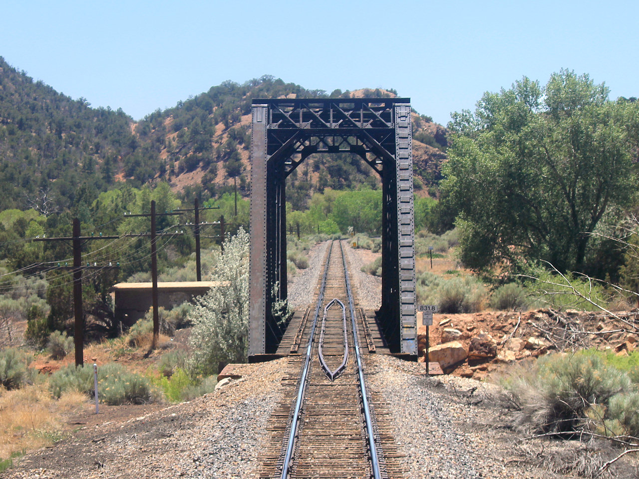
Truss bridge at MP 831.8.


We slowed to a stop at the CANYONCITO siding to meet our opposite westbound Train 3. I guess we were a bit early for the planned meet as we stopped on the main while 3 leapfrogged via the siding. This was the first CTC siding with power switches since Railrunner territory so I guess it can be tricky setting up movements here. Note the 20mph Approach PSR signals for Cougar Canyon and the Clear signal off the siding at West CANYONCITO interlocking. 


Train 3 was headed up by Amtrak P42DC's #131 and #116. Behind them was one of Amtrak's legit heritage baggage cars #1257.


End of Train 3 with Superliner #34056.


Rock cut east of the Canyoncito siding.


The Glorieta pass is also shared with Interstate 25, which will now shadow our trip just as I40 had across Arizona. Interesting how the interstate highway system effectively plagiarized the routes of the existing rail network instead of coming up with their own routes.


Moving on towards the Glorieta summit we find a pair of inert ATS inductors which warn trains of approaching severe speed restrictions. I also spotted another sign hinting of the lines past transporting heavy mainline freight trains.


The Glorieta Station is now a US post Office. This also marks the approximate location of the Glorieta Summit, some 7400 feet above sea level.


13-06-20 PHOTOS: Albuquerque Rail Runner

In Part Four of my Amtrak Southwest Chief trip across the country my train #4 turns off the BNSF Gallup Sub at DALIES and onto the Glorieta Sub which is part of the old Santa Fe Raton Pass line which follows close to the old Santa Fe trail. This part will cover the Glorieta Sub under the control of the New Mexico Rail Runner service as it runs up through Albuquerque and then continues on to Lamy, NM.

You can find the entire set of photos here and if you are interested in information on this and other BNSF Southwest Division subdivisions here.

The first part of the Glorieta Sub between Dalies and Isleta is one of those rail segments that made sense back when the BNSF still ran long distance freight trains over this route, but now only sees the daily back and forth of Amtrak's Southwest Chief. If the 60mph jointed rail track didn't remind you that you were off the main line this typical scene tends to hammer the point home.


Good news is we're back to classic signaling with searchlights and pole lines. Bad news is that the desert appears to be reclaiming the line.


At Isleta we get off the jointed rail and onto something with concrete ties. This part of the line has been recently upgraded for the New Mexico Railrunner commuter line between Belen and Santa Fe. Not long after we are across the River Big.


At this point is was time for lunch and when I was done eating my dessert the train had stopped. Getting out to stretch my legs I had no idea where we were, but looking around I saw a Mennonite farmer's market, historic ATSF locomotive shoppes, and commuter trains with a strange roadrunner theme. At that point I realized those things were indicative of the kind of bold railfanning they enjoy in...Albuquerque! Oh, and the station said Albuquerque too.


It was here that I finally got photos of our engines, P42DC #167 and #118, while they were being fueled. Compared with trains 5/6 and 7/8 this was about on part with the Builder's refueling station in Helen, MT, but well in advance of the Zephyr's of Denver.


Also hanging out at Albuquerque was protect engine #148 located in front of the old ATSF locomotive shoppes which have been out of service for some time.


The New Mexico Rail Runner were located across the trains from the station and MP36PH-3C #105 was under the maintenance shed. 


Also in attendance was Bombardier cab car #1007.


My photo loft as seen from the outside of the train. Amtrak was nice enough to have guys wash the windows on both sides of the train, but when I asked if he could wash off the end window it said he couldn't because that was a different craft or something so fuck it.


Passengers milling about on the through tracks. The Albuquerque station has a total of 4 platforms serving 4 tracks, but only two are really used for anything. 


13-06-20 PHOTOS: New Mexico Main Line

Welcome to the third part of my third cross country Amtrak rail adventure, this time featuring the Southwest Chief. In Part two I was traveling eastbound on the former ATSF double track transcontinental main line as my train blasted across Arizona at speeds upwards of 90mph. Here we begin again in Gallup New Mexico and will continue on to Dalies, NM where the Chief turns off the main line and onto the largely single track Raton pass route.

You can find all the photos from this and the previous set here and if you'd like more information on the BNSF Gallup Subdivision here

Starting off west of Gallup the right of way splits for some reason as we climb up to the Continental Divide. Here is a doublestack train on track #1 as seen from track #2.


Tree and a dump track with scenery. Nearby BNSF crews were repairing fence lines to keep cows off the track.


A second stack train headed west on track #1.


Here we see the Continental Divide at Campbell Pass, 7270 feet about sea level. While higher than the 5200 foot crossing on the Great Northern Hi-Line and not in a tunnel like the DRG&W Mofat route, the ATSF crossing is rather tame with no epic scenery and not even a sign to mark the occasion. Even more bizarre is that this isn't the high point on the line with two additional higher 7000+ foot crossings on the Raton Pass route.


Just east of the summit the tracks rejoin and we find C44-10W #7351 heading westbound towards and Approach Limited signal to cross back over behind our train at Gonzales interlocking.


Fellow C44-10W #7323 was on the rear pushing at Thoreau.


The Thoreau wye was being used as a transloading facility for non-conventional oil.


The tracks split again before we pass by some local color.


Autoracks and stacks seem way over on track 1 from track 2.


This corridor supported all forms of transportation from the ATSF railroad, to Interstate 40 and NM State Highway 122 to a dude on horseback.


At this point we star to pass eastbound intermodal trains on track #2 the first of which is lead by C44-10W #7865.


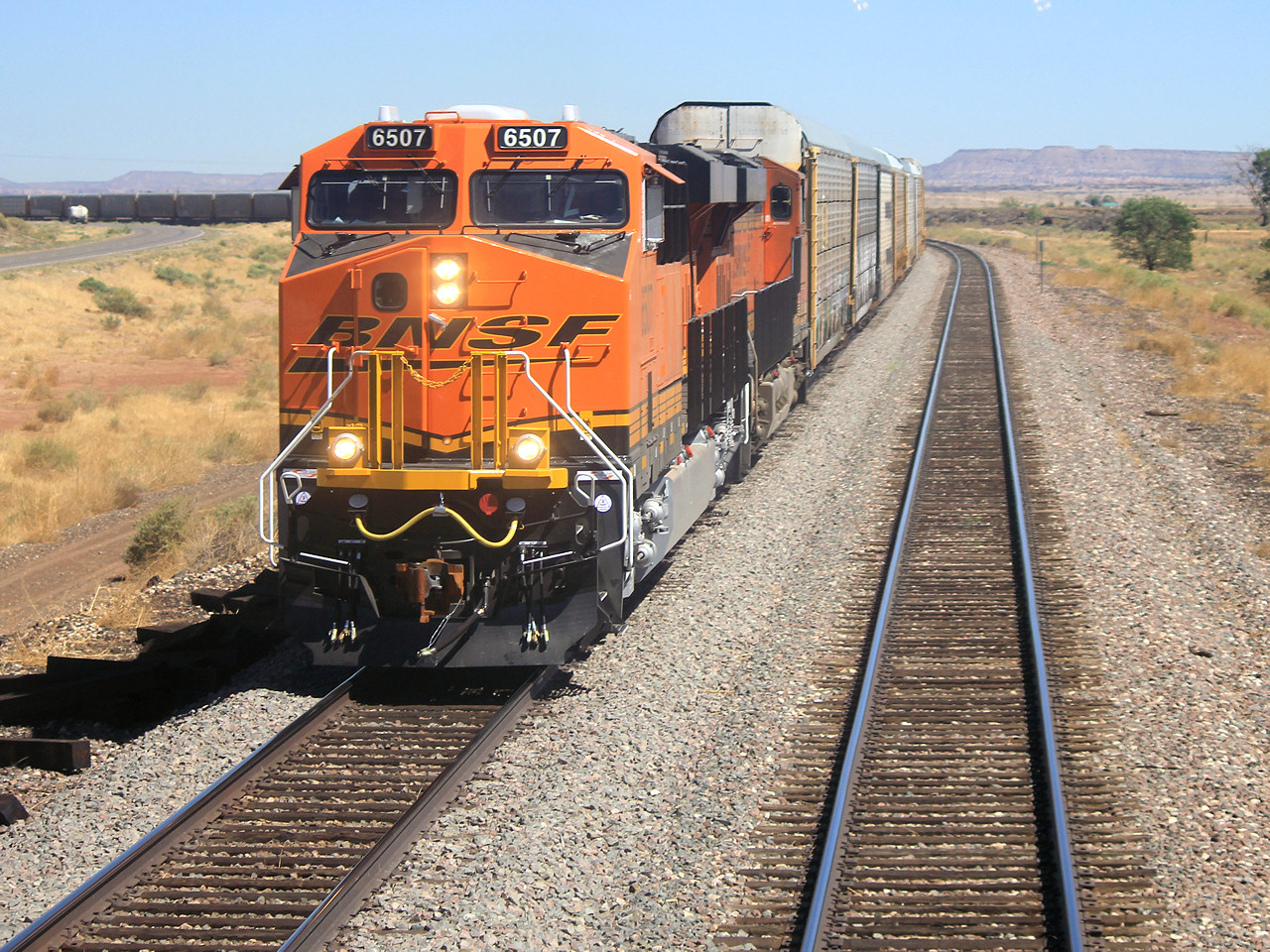
Next up in the Conga line is #6507 leading a string of autoracks. #6507 is the lead unit of the large ~2012 order of GE ES44C4's and was purchased singly to test out the 6 axle, 4 motor concept. 


Here's another new ES44C4 #6560 with doublestacks at Grants, NM.